Power your home
Enjoy price security with Safe Harbor fixed price energy plans
Enjoy price security with Safe Harbor fixed price energy plans
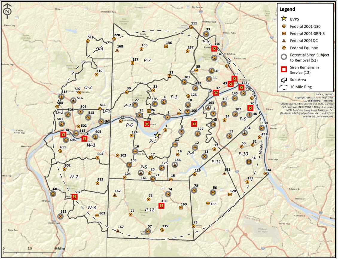
Outdoor Warning Sirens | 2021
The Beaver Valley Power Station continually works with the local Emergency Management Agencies to maintain a complex Alert and Notification System (ANS) within the 10-mile Emergency Planning Zone around the Beaver Valley Nuclear Power Station. The ANS is used to notify the public in the event of an emergency at the Beaver Valley Power Station. The ANS is comprised of outdoor warning sirens, county emergency alert systems, the national Emergency Alert System, and the national Integrated Public Alert and Warning System (IPAWS). The capabilities, use, and maintenance of the ANS system are reviewed and approved by the Federal Emergency Management Agency (FEMA).
Over the past several years, all the ANS outdoor warning sirens were upgraded to larger, more powerful sirens. These larger sirens can produce the required sound coverage for the 10-mile Emergency Planning Zone with fewer sirens. In 2020, an acoustical evaluation of the system was performed to thoroughly test the system performance and determine if the more powerful sirens rendered any of the existing sirens redundant. The acoustical evaluation results indicated that 66 sirens are needed to produce the required sound coverage for the 10-mile Emergency Planning Zone. The acoustical evaluation results indicated that 52 sirens were in areas that were covered by the sound of nearby sirens.
The ANS design report was revised to identify the 66 key sirens and remove the 52 sirens no longer required to provide appropriate coverage. FEMA reviewed and approved the report in 2020. The new ANS report requirements were implemented on Jan 1, 2021. At that time, the 52 redundant sirens were turned off. These sirens will be removed from their polls, over time.
Key Points:
Siren | Sub-Area | Siren Location |
2 | P-1 | Private property off Vance Road, Industry Boro |
3 | P-4 | Frankfort Road, Rt. 18 (LR #115), North of Holt Rd., Raccoon Township. |
4 | P-3 | Engle Rd (LR #04013), Rear of Snider Elementary School, Industry Boro |
7 | P-9 | Pleasant Drive (LR #04043), South of Rt. 18, Potter Twp. |
10 | P-3 | Barclay Hill Road (LR #04033) North of Vista Glen Drive, Industry Boro |
11 | P-1 | Rt. 18 (LR #115), South of Green Garden Road, Raccoon Township |
12 | P-4 | Patterson Rd (LR #04079), North of Green Garden Rd, Raccoon Twp |
13 | P-4 | Clearview Road (LR #04050), North of Davis Road, Raccoon Township |
16 | P-6 | Mill Street off Rt. 168 at Hookstown V.F.D., Hookstown Boro |
21 | P-5 | Rt. 30 (LR #538) near Hanover Township Line; Greene Township |
25 | P-1 | Midland Heights V.F.D. #2, Midland Boro |
27 | P-2 | fairview Midland Road, North of Eastwood Dr (LR #04108), Ohioville Boro |
33 | Outside 10-mile | Darlington Road (Rt. 588) Near Center Street, Chippewa Township |
36 | P-8 | Tuscarawas Road (LR #278), Near Pinkerton Drive, Brighton Township |
40 | P-9 | Center V.F.D. #3, Monaca Rd (LR #04019) near Linda Lane, Center Twp |
45 | P-9 | DLCo property, Raccoon Substation, Center Township |
46 | P-8 | Dutch Ridge Road (LR #04010), East of Wildwood Drive, Brighton Township |
51 | P-9 | Brodhead Road (Rt. 51) East of Maplewood, Center Township |
54 | P-10 | Forge Road off Brodhead Road (Rt. 51), Hopewell township |
56 | P-11 | Independence V.F.D. Rt. 51 (LR #445) and T-514, Independence Township |
57 | P-12 | Rt. 168 (LR #278) north of Frankfort Springs, Hanover Township |
73 | P-11 | Bocktown Road, Rt. 151 (LR #445) West of T-345, Independence Township |
74 | P-11 | Route 30 (LR #538) at Harshaville Substation, Hanover Township |
100 | P-3 | Route 68 (LR #243) near Barclay Hill Road (LR #04033) Industry Boro |
101 | P-7 | Off Tuscarawas Road (LR #278) at Barclay Substation, Brighton Township |
103 | P-6 | Route 168 (LR #278) and Route 30 (LR #538) intersection, Greene Township |
105 | P-3 | Kelly Road (LR #04080) south of Middle Road, Industry Boro |
106 | P-9 | Brodhead Rd at Rte 18 intersection near Beaver Valley Mall, Center Twp |
107 | P-9 | Center Grange Rd (LR #04074) at Biskup Ln (T-485) intersection, Center Twp |
122 | P-3 | Todd Road (T-500) off Sebring Road (LR #04041), Brighton Township |
125 | P-5 | Upper Service Road (T-307), Greene Township |
127 | P-4 | Hold Road (LR #04048), Raccoon Township |
130 | P-10 | Swimming Pool at 4th and Erie, West Aliquippa, Aliquippa Boro |
132 | P-9 | Taylor Avenue, Booster Station, Monaca Boro |
145 | P-9 | Old Brodhead Road near Clover, Center Township |
146 | P-4 | Shivler Rd (LR #04077) north of Frankfort Rd (Route 18), Raccoon Township |
147 | P-8 | Route 51 (LR #204) near Bradys Run Park, Patterson Township |
161 | P-5 | Old Mill Creek RD., Green TWP. |
163 | P-9 | RT. 18, 1 Mile South RT. 60, Potter TWP |
164 | P-10 | Temple RD., 1/2 Mile South Joe Rod., Hopewell TWP |
501 | O-2 | May Road off Route 427 and Boyd Road near Cemetary, Liverpool Township |
503 | O-1 | Elizabeth Street (route 39) near Harvey, City of East Liverpool |
505 | O-2 | Ada Street, Liverpool West V.F.D., Lacroft, Liverpool Township |
506 | O-2 | Lang Street off St. Clair Avenue (Rt. 428), City of East Liverpool |
512 | O-3 | Annasley Road north of Y&O Railroad, St. Clair Township |
513 | O-2 | Thompson Park Boulevard off Parkway, City of East Liverpool |
515 | O-2 | Jackson Street and Rural Lane, city of East Liverpool |
516 | O-3 | Church @ McKinney’s Furniture, ST. Clair TWP |
601 | Outside 10-mile | Rockeyside Rd (66/1) between Rt. 2 and Ferndale Rd (66/2), Clay District |
605 | W-1 | Route 16 and Lawrenceville V.F.D., Grant District |
606 | W-1 | Sixth Street (Rt. 1) off Rt. 2, Grant District |
612 | Outside 10-mile | Ridge Road (Route 20), New Cumberland Clay District |